
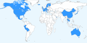
For those of us that want to track our travels, there are quite a few options out there. I’ve compiled a bunch of the online sites that allow you to create your own custom travel map with info and photos for comparison:
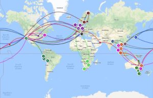
Traveller’s Point
https://secure.travellerspoint.com/
Pros: You can change the transportation mode for each leg of your journey to show plane/train/automobile… Each trip is shown as a different color. It uses Google Maps to show the geography. You can save your maps/trips and the site is a great place to maintain a travel blog with photos, etc!
Cons: It’s a bit labor intensive and tedious to enter all of your travels. The routes become cluttered looking. The site may be a bit more than you want, if you just want to show a big picture map of the countries you’ve been to.
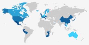
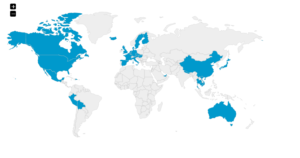
MatadorNetwork
http://matadornetwork.com/travel-map/
Pros: I like that it differentiates colors of countries for a colorful map and of course, my favorite color is blue, so what’s not to like? I chose this simplified version for my Destinations page, because it matches my blue theme.
Cons: This site won’t save your progress, so you have to re-do the map each time you want an update. Also, if blue ISN’T your favorite color, you aren’t able to change colors of countries.
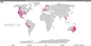
My Travel Map
Pros: This map lists all of your countries below and stats at the top “You have lived in 1, you have visited 64. You have explored 12.5% of the world.” which can be fun. Also, it differentiates states and provinces if you are into that sort of thing. It also shows the difference between born, lived and visited.
Cons: You can’t save your progress and can’t change the colors from this mauve theme, so good luck if you hate pink.
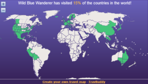
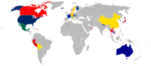
TravBuddy
http://www.travbuddy.com/world-travel-map
Pros: This one also differientiates states/provinces (or you can choose not to!). You can save the map to continue prograss and give’s you a status at the top (15% of the world traveled).
Cons: You can’t change the colors, though I feel like these might be pretty safe colors.
Google Maps
Pros: Just like a traditional wall map, it adds pins for each places you’ve been. You can change the colors of the pins, and add trips to different layers. There’s lots of zoom capability if you want to focus on a particular area. And, you can save if you have a google account.
Cons: Unlike some of the ones above, it doesn’t shade territories/countries, nor does it draw lines for your routes. There are no stats (ex. You’ve been to 349 cities).

Maploco
http://map1.maploco.com/visited-countries/
Pros: This is pretty rudamentary and easy to select, quickly. There are options for regional maps (USA, Canada, Europe), and the HTML for an embedded link.
Cons: They don’t show states or provinces on the world map, and you can’t change colors or save progress.
Where Have I Been
Pros: Similar to above, it has other regional maps. The countries are colorful and it counts them for you. It’s easily downloadable and printable to standard poster sizes. The background is invisible, which is great for printing.
Cons: You aren’t able to change the very primary, boyhood colors and the shapes of the countries are a bit over-simplified. Also, it lists countries in odd regions (Ex. Separates out the Middle East, but instead of doing the same for Oceania, Australia is in the continent of Asia. And, Mexico is listed as South America).
Big Huge Labs
http://bighugelabs.com/map.php
Pros: There are other, regional maps, and you can change the colors of the highlighted countries. You can’t login to save your work, but your cache will save your progress.
Cons: The small text and all countries organized in alphabetical order, without being sectioned into continents, is confusing.
Are there others that you love? Please share.